
Public Notice
Maryland Department of Natural Resources
Fishing and Boating Services
Application for Shellfish Aquaculture Lease – Maryland Seafood Cooperative, Inc. #495,
Somerset County
The Secretary of Maryland Department of Natural Resources (DNR), pursuant to Natural Resources
Article, §4-11A-09(g), Annotated Code of Maryland, is giving notice of an application for a shellfish
aquaculture submerged land lease by Maryland Seafood Cooperative, Inc. in the Manokin River oyster
sanctuary, Somerset County, Maryland, located approximately 1,353 feet west of St. Pierre Point and 1,390
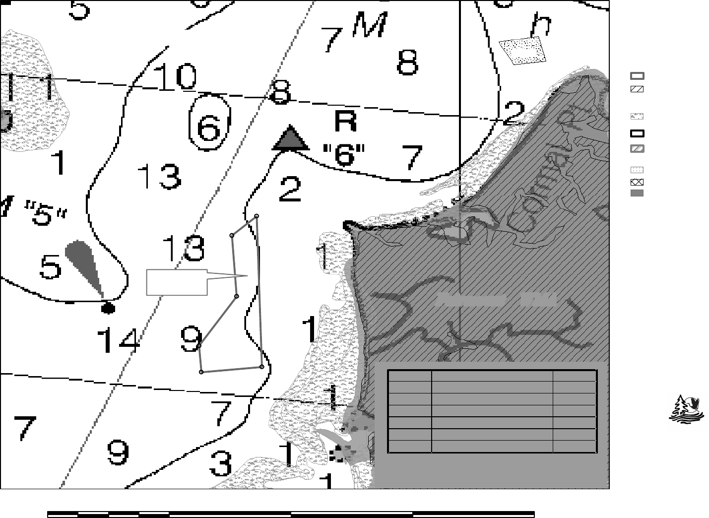
feet southwest of channel marker “6”. The area applied for contains 28.3 acres more or less and is enclosed
by a line beginning at corner 1, at or near Lat. 38° 7' 10.1" N., Long. 75° 50' 43.8" W., then running 356°
59' (True), approximately 139 meters to corner 2, at or near Lat. 38° 7' 14.6" N., Long. 75° 50' 44.2" W.,
then running 31° 3' (True), approximately 302 meters to corner 3, at or near Lat. 38° 7' 23" N., Long. 75°
50' 37.8" W., then running 357° 31' (True), approximately 321 meters to corner 4, at or near Lat. 38° 7'
33.4" N., Long. 75° 50' 38.6" W., then running 45° 9' (True), approximately 144 meters to corner 5, at or
near Lat. 38° 7' 36.7" N., Long. 75° 50' 34.4" W., then running 178° 25' (True), approximately 792 meters
to corner 6, at or near Lat. 38° 7' 11" N., Long. 75° 50' 33.5" W., then running 264° 41' (True),
approximately 252 meters to the point of beginning.
The applicant proposes to deposit oyster shell and spat-on-shell as needed within the given area to a
maximum depth of three inches high for the purpose of culturing Eastern Oyster (Crassostrea virginica),
and to harvest using methods approved by the Department. A map of the proposed lease is available on the
Fishing and Boating Services Public Notice web page,
dnr.maryland.gov/Fisheries/Pages/Pub_Notices.aspx.
The Department will hold a public informational meeting upon written request from a member of the
public. In addition, any person who has a specific right, duty, privilege, or interest that is different from that
held by the general public and may be adversely affected by the proposed lease may file a Petition of
Protest with the Department. Petitions that meet the requirements of Natural Resources Article
§4-11A-09(g) shall be forwarded to the Office of Administrative Hearings for adjudication. Comments,
written requests for a public informational meeting, and/or Petitions of Protest must be received by the
Department of Natural Resources Aquaculture and Industry Enhancement Division 580 Taylor Avenue E-4
Annapolis, MD 21401 by May 19, 2023. For questions about the project or the public notice, please contact
or 410-260-8252.
Josh Kurtz, Secretary
Maryland Department of Natural Resources
Point
Point
Cormal
St Pierre
SO809
Proposed Shellfish Submerged Land Lease NAV Chart Map
K
0 2,100 4,200 6,300 8,4001,050
Feet
Lease Area shown over
NOAA Raster
Navigational Charts.
Maryland Department of Natural Resources
Center for Geospatial Products and Services
580 Taylor Ave. E-2 Annapolis, MD 21401
410-260-8985 or 1-877-620-8DNR x8985
dnr.maryland.gov
DNR March 2023
Active Shellfish Lease
Proposed Shellfish Lease
Proposed Lease
Tidal Wetlands (NWI Wetlands)
(excludes E1 type)
Wetlands of Special State
Concern (MD-DNR)
Structures (Piers, Marinas, etc)
Submerged Aquatic Vegetation
(VIMS)
Land-Based-Sanctuaries and
Refuges (state, federal,
private, etc)
Wes Moore
Governor
Aruna Miller
Lt. Governor
Josh Kurtz
Secretary
David Goshorn
Deputy Secretary
Maryland Seafood Cooperative, Inc. #495 - Manokin River, Somerset County, Maryland
5
4
3
2
1
6
Fairmount WMA
Proposed Lease
28.3 acres
Manokin River
495
Corner markers will be used to mark the lease perimeter in
accordance with Natural Resources Article §4-11A-10 and
will be subject to U.S. Coast Guard approval.
Label Coordinates MLLW (ft)
1
38° 7' 10.1" N, 75° 50' 43.8" W
8.9
2
38° 7' 14.6" N, 75° 50' 44.2" W
9.2
3
38° 7' 23" N, 75° 50' 37.8" W
7.4
4
38° 7' 33.4" N, 75° 50' 38.6" W
9.6
5
38° 7' 36.7" N, 75° 50' 34.4" W
6.9
6
38° 7' 11" N, 75° 50' 33.5" W
6.4
